
LandMetrix™ OEM Agriculture Solution Toolkit
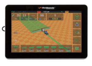
MAVERIX M10 TERMINAL

MAVERIX M7 TERMINAL

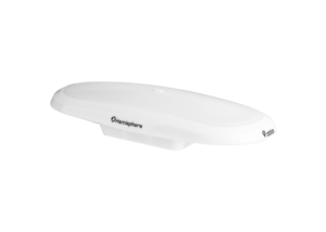
ESI WHEEL

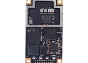
EDRIVE M1

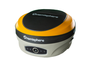
AC110

Introducing Hemisphere GNSS’ new OEM application software and hardware for building your agriculture guidance and control systems.
Hemisphere’s industry-leading technology empowers your applications using core hardware and software design services. Starting with your unique accuracy and durability requirements, we design solutions that promote your business values.
Hemisphere can create any agriculture guidance and control solution from the ground up. With a world-class in-house design and software team that develops the core technologies, to creating the GNSS OEM boards, and manufacturing the finished products, the possibilities are endless. Hemisphere will ensure that the right level of technology is built into each solution by working closely with the customer, from start to finish.
Both OEMs and end users who use the technology benefit from Hemisphere’s overall customer-first, service-oriented philosophy, giving customers the distinct ability to manage their business variables with technological flexibility and scalability.
Hemisphere’s LandMetrix OEM application software platform provides the ultimate tool for you to manage your machines for any guidance or control application. Whether it is land preparation, planting, spraying, or harvesting applications, you can re-brand the LandMetrix software to sell as your own.
Key Features
- Auto-steer guidance modes for AB, PIVOT, and
GRID patterns - Multiple steering interfaces
- Vehicle-specific installation kits
- NMEA2000 position output (with dynamic corrected position for control point)
- Ethernet capabilities
- Multiple terminal options
- Smart antenna and RTK base station options
Contact Our Team
Need to chat? Complete the form below and we will respond within 24 to 48 business hours.
Related Products

A631 GNSS Smart Antenna
- Scalable Dual-Frequency, Multi-GNSS
- GPS, GLONASS, BeiDou, and Galileo
- Athena™ RTK, Atlas® L-Band, and SBAS-Capable
- 800+ Channels
- 10 Hz Update Rate (20 Hz Optional)
OEM Development Kit ST
OEM Development Kit ST The Universal Development Kit ST allows you to integrate a Hemisphere GNSS OEM board into your design. The Universal Development Kit ST supports the following Hemisphere GNSS OEM boards:
- Vega™-based OEM boards
- Phantom™-based OEM boards
Related Products
Vector™ V123 & V133 GNSS Smart Antennas
- Single-Frequency, Multi-GNSS
- GPS, GLONASS, BeiDou, Galileo, and QZSS
- Beacon (V133), and SBAS-Capable
- 511 Channels
- 20 Hz Update Rate (50 Hz Optional)
- 0.3º Heading Accuracy
Vector™ V500 GNSS Smart Antenna
- Designed Specifically for Marine Applications
- Multi-Frequency, Multi-GNSS
- GPS, GLONASS, BeiDou, Galileo, QZSS, and IRNSS
- Athena™ RTK, Atlas® L-Band, and SBAS-Capable
- 1100+ Channels
- 10 Hz Update Rate (20 Hz Optional)
- 0.27º Heading Accuracy

Vector™ VR500 GNSS Smart Antenna
- Designed Specifically for Construction & Mining Applications
- Multi-Frequency, Multi-GNSS
- GPS, GLONASS, BeiDou, Galileo, QZSS, and IRNSS
- Athena™ RTK, Atlas® L-Band, and SBAS-Capable
- 1059 Channels
- 10 Hz Update Rate (20 Hz Optional)
- 0.27º Heading Accuracy
Phantom™ 40 GNSS OEM Board
- Multi-Frequency, Multi-GNSS
- GPS, GLONASS, BeiDou, Galileo, QZSS, and NavIC (IRNSS)
- Athena™ RTK, Atlas® L-Band, and SBAS-Capable
- 800+ Channels
C631 GNSS Smart Antenna
- Multi-frequency GPS, GLONASS, BeiDou, Galileo, QZSS, IRNSS, and Atlas L-band
- Long-range RTK baselines up to 50 km with fast acquisition times
- UHF (400 MHz & 900 MHz), cellular, Bluetooth, and Wi-Fi wireless communication
- Athena GNSS engine providing best-in-class RTK performance
- Internal sensor corrects collected point coordinates to within 2 cm
LandMetrix™ OEM Agriculture Solution Toolkit
LandMetrix™ OEM Agriculture Solution Toolkit
Introducing Hemisphere GNSS’ new OEM application software and hardware for building your agriculture guidance and control systems.
Vector™ V200 GNSS Smart Antenna
- Single-Frequency, Multi-GNSS
- GPS, GLONASS, BeiDou, Galileo, and QZSS
- SBAS-Capable
- 511 Channels
- 10 Hz Update Rate (20 Hz Optional)
- 0.75º Heading Accuracy
Phantom™ 20 & 34 GNSS OEM Boards
- Multi-Frequency, Multi-GNSS
- GPS, GLONASS, BeiDou, Galileo, QZSS, and NavIC (IRNSS)
- Athena™ RTK, Atlas® L-Band, and SBAS-Capable
- 800+ Channels

S631 GNSS Smart Antenna
- Multi-frequency GPS, GLONASS, BeiDou, Galileo, QZSS, IRNSS, and Atlas L-band
- Long-range RTK baselines up to 50 km with fast acquisition times
- UHF (400 MHz & 900 MHz), cellular, Bluetooth, and Wi-Fi wireless communication