
Marine
From nearshore to offshore, Hemisphere GNSS’ next-generation marine products and solutions bring you to new levels of precision, efficiency, and dependability.
OEMs (original equipment manufacturers), system integrators, and end-users rely on Hemisphere’s heading, positioning, and navigation solutions for professional, commercial, and recreational marine applications to withstand some of the harshest conditions from shallow waters and rough coastlines to unpredictable weather and wild seas.
Access to Advanced Technology Features
Hemisphere’s Atlas® is an innovative service that delivers correction signals via L-band satellites at scalable accuracies ranging from sub-meter to sub-decimeter levels. Leveraging more than 200 reference stations worldwide and L-band satellites distributing corrections, virtually all the earth’s landmass has coverage. Atlas support is available on all Atlas-capable Hemisphere multi-frequency hardware.
Using multi-frequency hardware, Atlas corrects all GNSS satellites to provide fast convergence times and allowing extremely robust and reliable usage near wharfs, piers, offshore rigs, cranes, and other overhead obstructions.
GNSS Compass Solutions
Hemisphere’s all-in-one Vector™ GNSS compass solutions provide precise heading and positioning for IMO (International Maritime Origanization)-wheelmarked applications, hydrogrpahic surveying vessels, fishing vessels, leisure boats, and other general marine navigation applications.
The rugged and reliable design of these compasses are ideal solutions to replace traditional gyrocompasses, at a fraction of the cost. Combining Hemisphere’s single and multi-freqeuncy technologies and multi-path resistant antennas, the Vector compasses bring a collection of robust features including heave, pitch, roll, output as well as NMEA 0183 and NMEA 2000 support.
Hemisphere’s integrated technologies and hardware supply marine applications in three market segments:
- Professional: Dreging and survey projects requiring up to 2 to 10 cm positioning accuracy and up to 0.01° (or better) heading accuracy.
- Commercial: Dredging projects and commercial navigation that necessitate sub-meter positioning accuracy and up to 0.5° heading accuracy.
- Recreational: Yachting and other general maritime applications which need 1° to 2° heading accuracy and 1 to 2 m accuracy for positioning.
Related Products
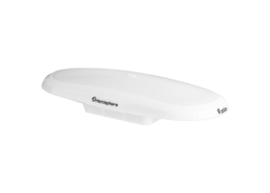
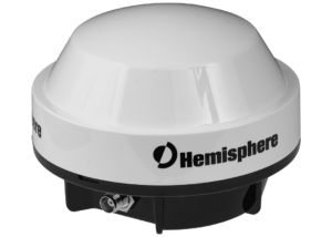
Vector™ V200 GNSS Smart Antenna
- Single-Frequency, Multi-GNSS
- GPS, GLONASS, BeiDou, Galileo, and QZSS
- SBAS-Capable
- 511 Channels
- 10 Hz Update Rate (20 Hz Optional)
- 0.75º Heading Accuracy
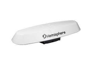
Vector™ V123 & V133 GNSS Smart Antennas
- Single-Frequency, Multi-GNSS
- GPS, GLONASS, BeiDou, Galileo, and QZSS
- Beacon (V133), and SBAS-Capable
- 511 Channels
- 20 Hz Update Rate (50 Hz Optional)
- 0.3º Heading Accuracy
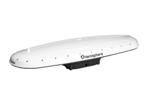
Vector™ V500 GNSS Smart Antenna
- Designed Specifically for Marine Applications
- Multi-Frequency, Multi-GNSS
- GPS, GLONASS, BeiDou, Galileo, QZSS, and IRNSS
- Athena™ RTK, Atlas® L-Band, and SBAS-Capable
- 1100+ Channels
- 10 Hz Update Rate (20 Hz Optional)
- 0.27º Heading Accuracy
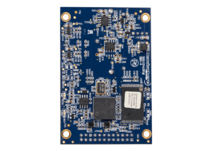
Vector™ VS1000 GNSS Receiver
- Designed Specifically for Marine Applications
- Multi-Frequency, Multi-GNSS
- GPS, GLONASS, BeiDou, and Galileo, IRNSS
- Athena™ RTK, Atlas® L-Band, and SBAS-Capable
- 1100+ Channels
- 10 Hz Update Rate (20 Hz Optional)
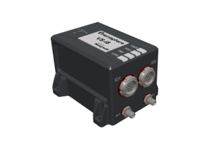
Vector™ VS-i8 Inertial Navigation System
- Vega 60 and Honeywell® sensor fusion technology
- Accurate time-stamped position, velocity, angular rate, linear acceleration, roll, pitch, heading
- Multi-Frequency, GPS, GLONASS, BeiDou, Galileo, QZSS, NavIC
- Athena™ RTK, Atlas® L-Band, and SBAS-Capable
- 1100+ Channels, 100 Hz INS
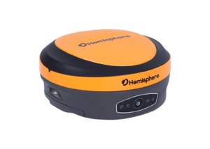
A631 GNSS Smart Antenna
- Scalable Dual-Frequency, Multi-GNSS
- GPS, GLONASS, BeiDou, and Galileo
- Athena™ RTK, Atlas® L-Band, and SBAS-Capable
- 800+ Channels
- 10 Hz Update Rate (20 Hz Optional)
S631 GNSS Smart Antenna
- Multi-frequency GPS, GLONASS, BeiDou, Galileo, QZSS, IRNSS, and Atlas L-band
- Long-range RTK baselines up to 50 km with fast acquisition times
- UHF (400 MHz & 900 MHz), cellular, Bluetooth, and Wi-Fi wireless communication
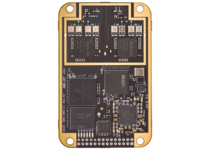
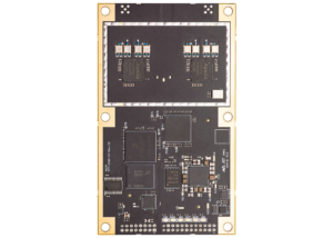
Vega™ 28 GNSS Compass Board
- Multi-Frequency, Multi-GNSS
- GPS, GLONASS, BeiDou, Galileo, QZSS, and NavIC (IRNSS)
- Athena™ RTK, Atlas® L-Band, and SBAS-Capable
- 1,100+ Channels
Vega™ 40 GNSS Compass Board
- Multi-Frequency, Multi-GNSS
- GPS, GLONASS, BeiDou, Galileo, QZSS, and NavIC (IRNSS)
- Athena™ RTK, Atlas® L-Band, and SBAS-Capable
- 1,100+ Channels
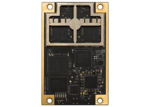
Vega™ 60 GNSS Compass Board
- Multi-Frequency, Multi-GNSS
- GPS, GLONASS, BeiDou, Galileo, QZSS, and NavIC (IRNSS)
- Athena™ RTK, Atlas® L-Band, and SBAS-Capable
- 1,100+ Channels
SBX-4 DGPS Beacon OEM Board
- Beacon Module
- 2-Channel Parallel Tracking
- 500 Hz Channel Spacing
A42 Antenna
- Multi-Frequency, Multi-GNSS
- GPS L1/L2/L5, GLONASS L1/L2, BeiDou, and Galileo E1/E5a/E5b
- SBAS-Capable
A43 Antenna
- Multi-Frequency, Multi-GNSS
- GPS L1/L2/L5, GLONASS L1/L2, BeiDou, and Galileo E1
- Beacon and SBAS-Capable
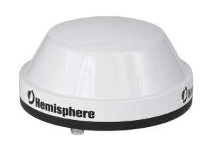
A65 Antenna
The A65 GNSS antenna is engineered to deliver millimeter level accuracy for both land and marine applications. It supports current and future GNSS signals, including GPS, GLONASS, BeiDou, and Galileo, ensuring long-term reliability.